As the economy of North Carolina continued to grow, the amount of goods transported by boat grew as well. As the shipping traffic increased, local rivers enabled ships to transport their cargo to the local port cities where it would be unloaded and sent off to its intended destination. One of the major cities, which took advantage of the maritime traffic, is the town of Wilmington. Located several miles inland on the banks of the Cape Fear River, it was quickly realized that ships headed to Wilmington needed some assistance navigating the river.
The US Lighthouse Establishment began the process of establishing a series of range lights along the banks of the river, strategically placed to guide the ships safely to port. In 1850, the Prices Creek Range lights were established near the present day town of Southport.
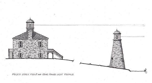
The Typical design of range lights included a short tower, which would be constructed close to the river with an accompanying taller tower located further inland behind the shorter tower. As the ship captains navigated their ships up the river, the captain would line up the two lights, one over the other to indicate that the ship was on safe course. However, when the top light (light from the rear range light) appeared to tilt left or right, action was taken to correct the course of the ship.
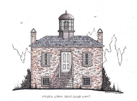
In the case of the Prices Creek range lights; the front range tower was constructed to a height of 20 feet and located near the water. The rear range tower was a square brick structure, twenty-five feet by twenty-five feet, which also served as the keeper’s
Brent Westwood sketched these wonderful artist's rendering of the Prices Creek Rear Range Lighthouse (above) which no longer exists. In the "elevation profile" shown below, the front and rear range lights are drawn to scale, based on historical information. However, the distance is abbreviated because of the 800-1,000 foot spacing between the front and rear range lights. This "elevation profile" presents a side view of both lighthouses as they may have looked during their years of operation.
©2005 All rights reserved.
quarters. The lantern room was placed on top of the structure giving it an overall height of approximately 35 feet and located about 700-800 feet behind the front range tower. Both towers made use of a sixth-order Fresnel lens, which gave off a fixed white light from a “bird-cage” style lantern room.
These two lighthouses worked in tandem until the outbreak of the Civil War. During the early days of the war, the confederates used the towers to aid the blockade-runners, allowing needed supplies to be shipped into and out of the Confederate States. As the Union Army took control of more and more of coastal North Carolina, the Confederate Soldiers had to retreat inland. One of their last acts as they left the area was to damage/destroy the structures to keep them from being used by the Union Army and they were quite successful at doing so. After the Civil War, it was deemed that the pair of lights was no longer needed and the two lighthouses were decommissioned.
Today, the ruins of the front range lighthouse are all that remains. Currently owned by Archer-Daniels, the lighthouse is off limits and inaccessible to the public.